Course
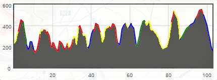
1.) 103 km PUT ULTRA course (to see the course map click this link)
The main PUT course has 103 km / +3.500 m parameters, it follows the tourist marked paths through Small Carpathians, through the Bratislava city and the town Stupava as well as through the village Marianka.
ULTRA course description:
Dúbravka - Dúbravka, kostol (church) - Dúbravská hlavica - Bočná cesta - Rovnica - Lipové - Sandberg - Pod Devínskou Kobylou - Devín (parking place neerby the castle) - Úzky les - Dúbravská hlavica - Švábsky vrch - Jezuitské lesy - Kútiky - Mlynská dolina - Slavín - Pri Červenom moste - Červený most - Klanec - Kamzík - Pod Chlmcom - Pekná cesta, záhrady - Spariská - Pod Chlmcom - Snežienka - Za Kačínom - Sekyl - Marianka - Malinský vrch - Pánova lúka - Vypálenisko - Rača, amfiteáter - Zbojníčka - Bystrické - Svätý vrch - Klčovanice - Stupava - Stupava, Obora - Pajštún - Pod kozliskom - Pod Dračím hrádkom - Medené hámre - Košarisko - Salaš - Biely kríž - Rača, finish in Culture center Žarnovická
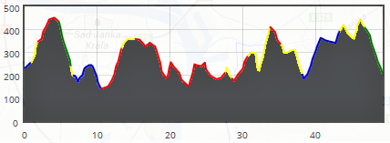
2.) 50 km PUT MINI-ULTRA course (to see the course map click this link)
A part of the PUT event is also a half-distance (50 km / +1.850 m) course.
MINI-ULTRA course description:
Dúbravka - Dúbravka, kostol (church) - Dúbravská hlavica - Bočná cesta - Rovnica - Lipové - Sandberg - Pod Devínskou Kobylou - Devín (parking place neerby the castle) - Úzky les - Dúbravská hlavica - Švábsky vrch - Jezuitské lesy - Kútiky - Mlynská dolina - Slavín - Pri Červenom moste - Červený most - Klanec - Kamzík - Pod Chlmcom - Pekná cesta, záhrady - Spariská - Malinský vrch - Pánova lúka - Zbojníčka - Rača, finish in Culture center Žarnovická
GPX file for the 50 km course (author: Peter Bilik) ca be downloaded HERE.
3.) LIve checkpoints - position and time limits
| Checkpoint | Position | Map | Km from start | Time limit |
| K1 | Dúbravská hlavica (next to the bike signpost) | Link | 2,5 km | W/a limit |
| K2 | Devín (parking place close to the Devín castle) | Link | 11 km | Till 09:30 |
| K3 | Dúbravská hlavica (next to the bike signpost) | Link | 15 km | Till 10:30 |
| K4 | Horský park (Forest school) | Link | 25 km | Till 13:00 |
| K5 | Kamzík (buffet Kamzík) | Link | 34 km | Till 15:00 |
| K6 | Pekná cesta, záhrady (tent at signpost) | Link | 38,5 km | Till 17:00 |
| K7 | Marianka (U Zeleného stromu - pub) | Link | 55 km | Till 20:00 |
| K8 | Stupava (Šenk Mlyn - pub) | Link | 77 km | Till 24:00 |
| K9 | Košarisko (tent) | Link | 92 km | Till 03:30 |
The 50 km MINI-ULTRA course has only checkpoints K1 - K6 (not K7, K8 and K9).
In case of checkpoint position change we will inform you before start.
4.) Course marking
The course follows the tourist marks through Small Carpathians, through the Bratislava city, smaller town Stupava and also village Marianka.
Information about own PUT marking will be added soon.
5.) Type of terrain
Very diverse - forest paths, tracks and drivable tracks, stony paths, metalled roads, tarmac paths and roads. Longer tarmac passages are between Mlynská Dolina and Červený most, from Rača amphitheatre signpost to Zbojníčka, from Stupava to Stupava Obora and from Medené Hámre to Košarisko.
6.) Warnings
- The passage between Švábsky vrch and Jezuitské lesy signposts overlaps with the part of 6500 m course of the Devínska Kobyla Run (which usually takes place on the same day). The runners start for the 6500 m course at 12.00, so youn might not meet them. However, due to this (to avoid conflict in marking) in the passage between this point and this point there will be no PUT marking. You have to follow the red tourist mark there.
- The course does not go to the Slavín military monument, it turns left to Horský park at the Slavín signpost.
- The course from signpost Pri Červenom moste to Červený most (Red bridge) goes through the forest, after the descent you will come to the Partizánska lúka (meadow with sports grounds), go up the stairs and then to Červený most (Red bridge). Do not go to Vojenská nemocnica (Military hospital).
- In Stupava town you will come to the local church through the Pri Borníku street and Kalvárska street (follow the amber marks made with airbrush).
- The path from Dračí hrádok to the road (Pod Dračím hrádkom) is often being damaged by woodmen and muddy, be careful here.
- At Košarisko - do not go to the red, blue and green tourist marks crossing, the course turns right at the first green and blue tourist mark crossing.
- From Biely kríž the blue marked tourist path goes paralelly with the tarmac road (on the right side of the tarmac road).